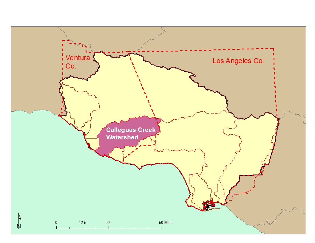
Calleguas Creek and its major tributaries, Revolon Slough, Conejo Creek, Arroyo Conejo, Arroyo Santa Rosa, and Arroyo Simi drain an area of 343 square miles in southern Ventura County and a small portion of western Los Angeles County. This watershed, which is elongated along an east-west axis, is about 30 miles long and 14 miles wide. The northern boundary of the watershed is formed by the Santa Susana Mountains, South Mountain, and Oak Ridge; the southern boundary is formed by the Simi Hills and Santa Monica Mountains.
Land uses vary throughout the watershed. Urban developments are generally restricted to the city limits of Simi Valley, Moorpark, Thousand Oaks, and Camarillo. Although some residential development has occurred along the slopes of the watershed, most upland areas are still open space; however, golf courses are becoming increasingly popular to locate in these open areas. Agricultural activities, primarily cultivation of orchards and row crops, are spread out along valleys and on the Oxnard Plain as shown in the figure below.

Mugu Lagoon, located at the mouth of the watershed, is one of the few remaining significant saltwater wetland habitats in southern California. The Point Mugu Naval Air Base is located in the immediate area and the surrounding Oxnard Plain supports a large variety of agricultural crops. These fields drain into ditches which either enter the lagoon directly or through Calleguas Creek and its tributaries. Other fields drain into tile drain systems which discharge to drains or creeks. Also in the area of the base are freshwater wetlands created on a seasonal basis to support duck hunting clubs. 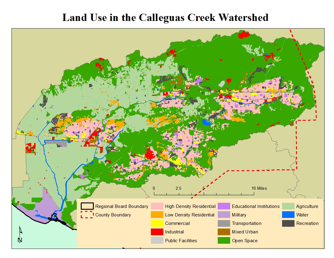 The lagoon borders on an Area of Special Biological Significance (ASBS) and supports a great diversity of wildlife including several endangered birds and one endangered plant species. Except for the military base, the lagoon area is relatively undeveloped.
Supplies of ground water are critical to agricultural operations and industry (sand and gravel mining) in this watershed. Moreover, much of the population in the watershed relies upon ground water for drinking.
Water Quality Problems and Issues
 Aquatic life in both Mugu Lagoon and the inland streams of this watershed has been impacted by pollutants from nonpoint sources. DDT, PCBs, other pesticides, and some metals have been detected in both sediment and biota collected from surface waterbodies of this watershed. Additionally, ambient toxicity due to pesticides such as diazinon and chlorpyrifos occurs (ammonia from POTWs before they implemented treatment upgrades also contributed to toxicity). Fish collected from Calleguas Creek and Revolon Slough exhibited skin lesions in early studies and were found to have other histopathologic abnormalities. High levels of minerals and nitrates are common in the water column as well as in the groundwater. Sediment toxicity is also elevated in some parts of the lagoon. Reproduction is impaired in the resident endangered species, the light-footed clapper rail due to elevated levels of DDT and PCBs. Overall, this is a very impaired watershed. It appears that the sources of many of these pollutants are agricultural activities (mostly through continued disturbance and erosion of historically contaminated soils), which cover approximately 25% of the watershed along the inland valleys and coastal plain, although the nearby naval facility has also been a contributor. Other nonpoint sources include residential and urban activities, which are present over approximately 25% of the watershed. The remaining 50% of the watershed is still open space although there is a severe lack of benthic and riparian habitat.
A considerable amount of water quality data are available on the California Environmental Data Exchange Network at http://www.ceden.org and on the My Water Quality web portal at http://www.mywaterquality.ca.gov/index.shtml. Clean Water Act Section 303(d) impairments in the watershed are predominantly from excessive pesticides, nutrients, and salts. Click on the link to obtain a complete list of impairments.
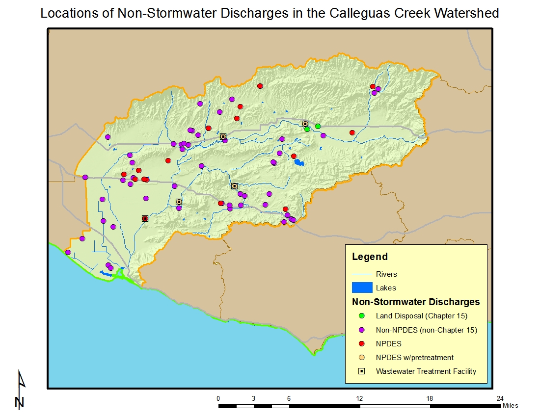 All discharges from point sources (a pipe or outfall) to surface waters are required to be regulated by federal National Pollutant Discharge Elimination System (NPDES) permits while discharges to land are regulated by State Waste Discharge Requirements (WDRs, often called non-NPDES permits). The locations of facilities with discharges to surface water or to the ground (other than those covered by general industrial or construction stormwater permits) are shown in the figure to the left. Major NPDES discharges are from either POTWs with a yearly average flow of over 0.5 MGD, from an industrial source with a yearly average flow of over 0.1 MGD, or are those discharges with lesser flows but with potential acute or adverse environmental impacts to surface waters. Minor NPDES discharges are all other discharges to surface waters that are not categorized as a Major. Minor discharges may be covered by general NPDES permits, which are issued administratively, for those that meet the conditions specified by the particular general permit.
 Non-NPDES (non-Chapter 15) discharges are those to land or groundwater such as commercial septic systems or percolation ponds that are covered by Waste Discharge Requirements, a State permitting activity. Chapter 15 discharges generally relate to land disposal (landfills) under Chapter 15 of the California Code of Regulations, again an exclusively State permitting activity.
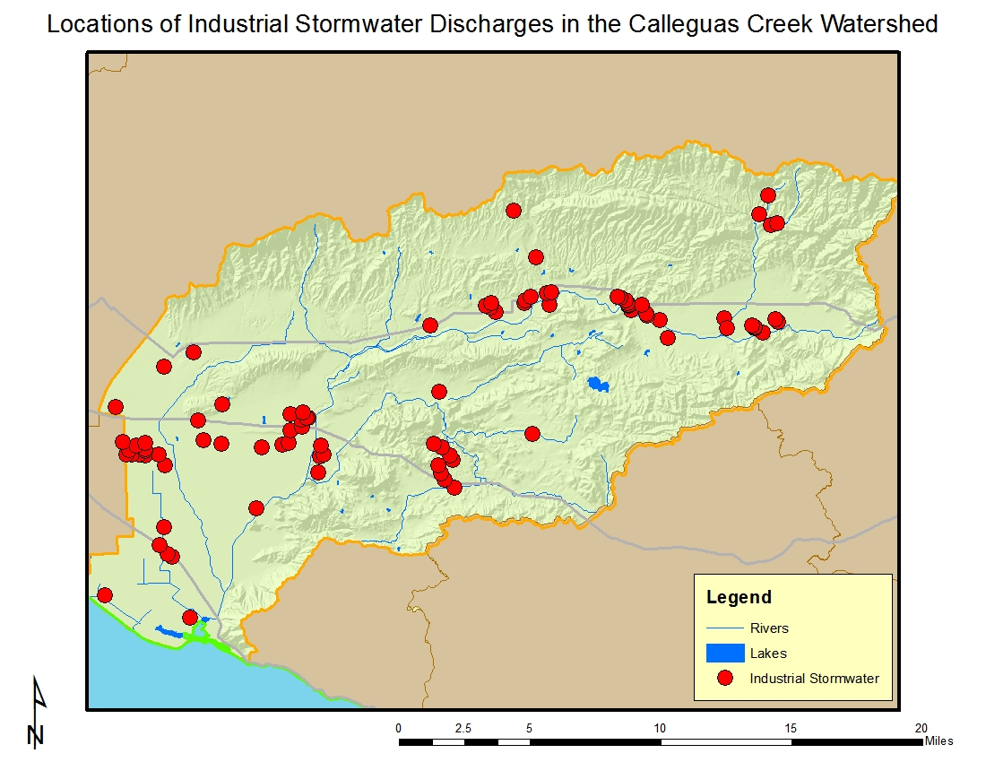
Of the 93 dischargers enrolled under the general industrial storm water permit in the watershed (see figure to right), the largest numbers are located in the cities of Simi Valley and Camarillo. There is a diverse mix of industries represented including electric, gas and sanitary services; local and interurban passenger transit; electric and electronic equipment; and stone, clay and glass products based on their Standard Industrial Classification (SIC) codes. The general industrial stormwater permit is issued by the State Water Resources Control Board; more information can be found at https://www.waterboards.ca.gov/water_issues/programs/stormwater/industrial.shtml.
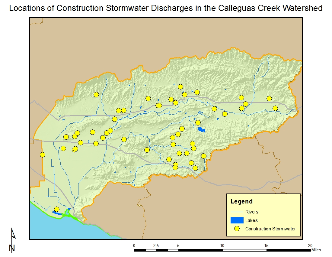
There are 80 construction sites enrolled under the general construction storm water permit. About one-half of the sites are residential and about one-half are five acres or larger in size; one site is about 1,000 acres. Most of the sites are located in Camarillo, Simi Valley, and Thousand Oaks. The locations of facilities with discharges covered by the general construction stormwater permit are shown in the figure below. The general construction stormwater permit is issued by the State Water Resources Control Board; more information can be found at https://www.waterboards.ca.gov/water_issues/programs/stormwater/construction.shtml.
Click on the link for a complete list of permits in the watershed.
Regional Board Actions to Address Impairments
A number of Regional Board programs and actions are in place to address the water quality impairments noted earlier.
Total Maximum Daily Loads (TMDLs) have been developed (as required by the Clean Water Act) for many of the impairments in the watershed. The TMDL is a number that represents the assimilative capacity of a receiving water to absorb a pollutant and is the sum of the individual wasteload allocations for point sources, load allocations for nonpoint sources plus an allotment for natural background loading, and a margin of safety. TMDLs can be expressed in terms of mass per time (the traditional approach) or in other ways such as toxicity or a percentage reduction or other appropriate measure relating to a water quality objective. A TMDL is implemented by reallocating the total allowable pollution among the different pollutant sources (through the permitting process or other regulatory means) to ensure that the water quality objectives are achieved. TMDLs in effect in all or parts of the watershed include those for salts, toxicity, nitrogen, trash, metals, and organochlorine pesticides & PCBs. Additional information on these TMDLs may be found at https://www.waterboards.ca.gov/losangeles/water_issues/programs/tmdl/.
Toxicity due to ammonia was previously a major issue in the watershed. As a result, POTWs were required to meet lower ammonia concentrations in their effluent; their treatment processes have been modified to achieve these new limitations. Copies of permits may be found at https://www.waterboards.ca.gov/rwqcb4/board_decisions/adopted_orders/by_permits_tools.shtml
A number of TMDLs contain load allocations assigned to irrigated agriculture. The Regional Board adopted a conditional waiver for discharges from irrigated lands (see https://www.waterboards.ca.gov/losangeles/water_issues/programs/tmdl/waivers/index.shtml) which requires agricultural interests to monitor and implement various best management practices as needed to improve the quality of runoff from irrigated lands. This can be accomplished by growers either individually or through joining a group effort; in the Calleguas Creek Watershed they may join the Ventura County Agriculture Irrigated Lands Group (VCAILG). More information on VCAILG may be found on the Farm Bureau of Ventura County’s website at http://www.farmbureauvc.com/water_quality.html.
Storm water (wet weather) and non-storm water (dry weather) discharges from the municipal separate storm sewer systems (MS4), or storm drain system, within Ventura County are addressed by an NPDES Permit issued to the Ventura County Watershed Protection District (as the Principal Permittee), County of Ventura, and the incorporated cities within. The permit effectively prohibits non-storm discharges into the MS4 and receiving waters with certain exceptions. It also requires that treatment control BMPs be designed to meet certain performance criteria, that each Permittee implement programs and measures to comply with the TMDLs’ waste load allocations for the MS4 specified in the permit, and that regular inspections of various types of commercial facilities be undertaken. A monitoring program must also be implemented. More information about this permit may be found at https://www.waterboards.ca.gov/losangeles/water_issues/programs/stormwater/municipal/index.shtml#ventura. Results from water quality monitoring may be found at http://www.vcstormwater.org/apps/stormwater/.
Activities Led by Watershed Stakeholders
Recognizing that many of the water quality problems in the lagoon stem from land use practices and pollutant sources above the lagoon, the Calleguas Creek Watershed Management Committee and Technical Subcommittees were formed in 1996 to exchange data and discuss coordinated approaches to solving the many problems in this watershed, including development of a watershed management plan. Besides the main management committee of stakeholders, technical subcommittees deal with more specific issues such as water quality, flood protection/ sediment management, habitat/open space/recreation, public outreach, and land use. These groups now also aid with development and implementation of the Integrated Regional Water Management Plan (IRWMP) developed for Ventura County as part of the Watersheds Coalition of Ventura County. Further information concerning the management and technical committees may be found at http://www.calleguas.com/ccbrochure/cc.htm. Additional information about the Watersheds Coalition of Ventura County may be found at http://www.watershedscoalition.org.
In 2011, study was conducted in the Ventura County coastal plain entitled “Historical Ecology of the lower Santa Clara River, Ventura River, and Oxnard Plain: an analysis of terrestrial, riverine, and coastal habitats” that is available for download at ftp://ftp.sccwrp.org/pub/download/DOCUMENTS/TechnicalReports/662_VenturaCo_HistoricalEcology.pdf. The area covered by the study includes a portion of the Calleguas Creek Watershed and may serve as an important planning tool in any future wetlands restoration work.