LARWQCB 2025 Post-Fire Water Quality Monitoring
After wildfires, debris and ash containing pollutants can wash off into rivers and beaches and wash back onshore from the ocean. In the wake of the recent devastating fires in the region, the Los Angeles Regional Water Quality Control Board has several ongoing water quality monitoring efforts.
Ocean Water Quality Sampling
The board has been working with Los Angeles County to monitor ocean water quality since January 22, 2025. Samples are collected regularly at 12 beach sites from La Costa Beach to Dockweiler Beach by the Los Angeles County Department of Public Health. They then are analyzed by the board for metals, nutrients, polychlorinated biphenyls (PBCs) and polycyclic aromatic hydrocarbons (PAHs), which are chemicals that may be found in water runoff based on previous California wildfires.
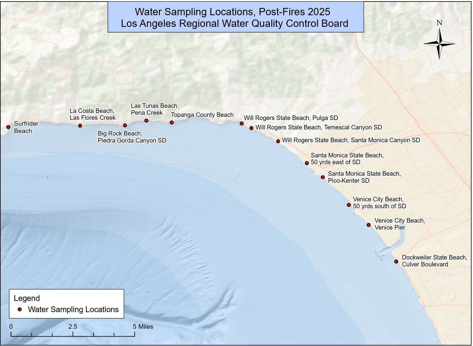
Ocean Water Quality Sampling Sites
| DPH-002 | Surfrider Beach |
| SMB-1-14 | La Costa Beach at Las Flores Creek |
| SMB 1-16 | Las Tunas Beach at Pena Creek |
| DPH 001 | Big Rock Beach at Piedra Gorda Canyon SD |
| SMB 1-18 | Topanga County Beach at Topanga Canyon Lagoon |
| SMB 2-4 | Will Rogers State Beach at Pulga SD |
| DPH 103 | Will Rogers State Beach at Temescal Canyon SD |
| SMB 2-7 | Will Rogers State Beach at Santa Monica Canyon SD |
| DPH 105B | Santa Monica State Beach |
| SMB 3-4 | Santa Monica State Beach at Pico-Kenter SD |
| DPH 107B | Venice City Beach |
| DPH 108 | Venice Pier |
| SMB 2-10 | Dockweiler State Beach at Culver Boulevard |
Ocean Water Quality Results
- January 22, 2025 Results
- January 27, 2025 Results
- February 6, 2025 Results
- February 18, 2025 Results
- March 13, 2025 Results
- Analysis of Ocean Water Quality Data
- May 1, 2025 Results
- May 1, 2025 - PAHs and PCBs
- Analysis of Ocean Water Quality Data May 2025 update
The board compared ocean water quality results with U.S. EPA risk-based screening levels for recreation in water and Ocean Plan objectives for consumption of fish. All results were below these values, except for arsenic at multiple sites and two PAHs at two sites during the first event. However, these arsenic and PAH levels were within the pre-fire range of concentrations in Southern California, and therefore, were not likely caused by the fire. Arsenic is a common and naturally occurring element found in the region.
The Los Angeles County Department of Public Health uses these data to make decisions, including whether to issue beach advisories. The public should not rely on the results posted here when planning visits to these beaches but rather follow up-to-date ocean water advisories and closures issued by the Department of Public Health by calling their advisory hotline 1-800-525-5662 or visiting publichealth.lacounty.gov/beach.
Sediment/Beach Sand Sampling
The board is testing sediment and sand for chemicals associated with wildfires—such as heavy metals, PBCs and PAHs—at 11 beaches and four storm drain/creek outfalls along Santa Monica Bay from Zuma Beach to RAT Beach.
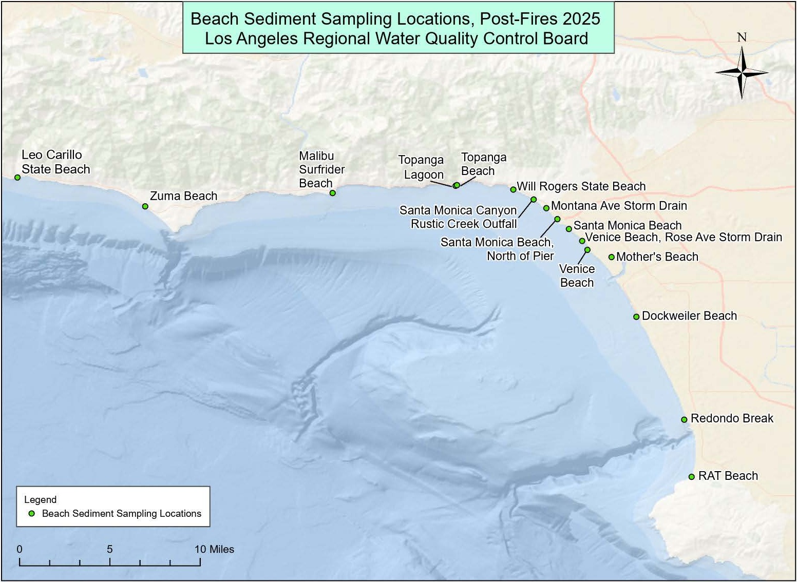
Sediment Sampling Sites
| Leo Carillo State Beach |
| Zuma Beach |
| Surfrider Beach |
| Topanga County Beach |
| Topanga Canyon Lagoon |
| Will Rogers State Beach |
| Will Rogers State Beach at Santa Monica Canyon |
| Montana Avenue Storm Drain |
| Santa Monica Beach North of Pier |
| Santa Monica Beach |
| Rose Avenue Storm Drain |
| Venice Beach |
| Mothers Beach |
| Dockweiler Beach |
| Redondo Break |
| RAT Beach |
Sediment/Beach Sand Results
Sampling began on February 25, 2025 and will continue through May 2025.
- February 25-27, 2025 Results - Metals
- February 25-27, 2025 Results – PAHs and PCBs
- Analysis of Sediment/Beach Sand Data February 25-27, 2025 Results
- April 29-30, 2025 Results - Metals
- April 29-30, 2025 Results – PAHs and PCBs
- Analysis of Sediment / Beach Sand Data April 29-30, 2025 Update - HexCr Added
The board compared sediment/beach sand results with U.S. EPA risk screening levels for residential soil and California-specific risk screening levels for residential soil in the Los Angeles region. All results were below these values, except for arsenic at multiple sites and events. However, these arsenic levels were within the pre-fire range of concentrations in Los Angeles area soils, and therefore, were not likely caused by the fire. Arsenic is a common and naturally occurring element found in the region.
The Los Angeles County Department of Public Health uses these data to make decisions, including whether to issue beach advisories. The public should not rely on the results posted here when planning visits to these beaches but rather follow up-to-date ocean water advisories and closures issued by the Department of Public Health by calling their advisory hotline 1-800-525-5662 or visiting publichealth.lacounty.gov/beach.
Coordination of Regionwide Monitoring
The board has contracted with the Southern California Coastal Water Research Project to coordinate the monitoring efforts of other government agencies, academic institutions, and nonprofits to ensure that appropriate methodologies are used and high-quality data are generated. The project will:
- create and facilitate an interagency, post-wildfire workgroup to ensure that adequate water quality monitoring is performed;
- identify key sites and indicators to be monitored;
- develop a set of recommended sampling and analytical methods, quality assurance and quality control measures, and data reporting requirements; and
- coordinate sampling efforts to leverage resources.
For more information about SCCWRP's activities please contact Dr. Alvina Mehinto at SCCWRP.
Please visit the State Water Board 2025 Los Angeles Wildfire Recovery webpage for more information about the Water Boards’ response to the recent wildfires.
Data is being uploaded on a regular basis to a website maintained by the Los Angeles County Department of Public Health.
