Guide for the EWRIMS Public Database
This guide is intended to assist the public with general inquiries about the use of the Electronic Water Rights Information Management System (eWRIMS) Database System (Public Water Rights Database). Using this guide, you will be able to conduct basic database searches. Such as Water Rights Record Search, Water Rights Web Mapping Application, and the Water Rights Progress Reports – Annual Water Use Report (search).
Access the e-WRIMS - Public Data Access Menu.
Note: For term definitions see the Data Dictionary and Definitions section of this guide.
Questions? Contact the eWRIMS Program at: eWRIMS@waterboards.ca.gov
Water Rights Record Search
About
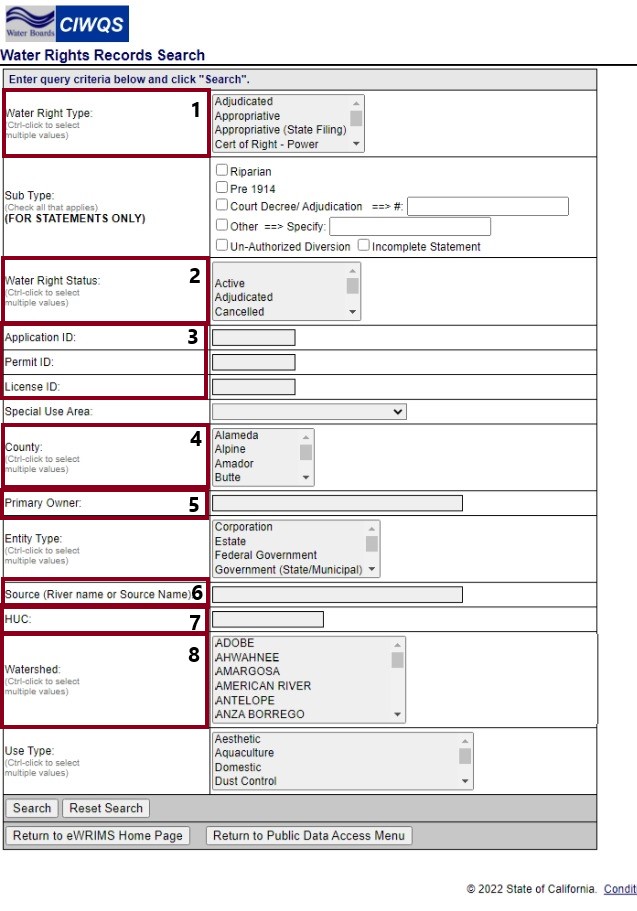
Allows for the search of water right records in the database. Searches can be performed by filtering several parameters, including water right record id, water right type, status, primary owner name, and county. Search results and individual record information is available to be viewed and downloaded as a comma separated value file.
Note: See the Data Dictionary and Definitions section of this guide to better understand search fields and terms.
Database Anatomy Highlights
- Water Right Type
- Water Right Status
- Application ID / Permit ID / License ID
- County
- Primary Owner
- Source
- HUC
- Watershed

Water Rights Web Mapping Application
About
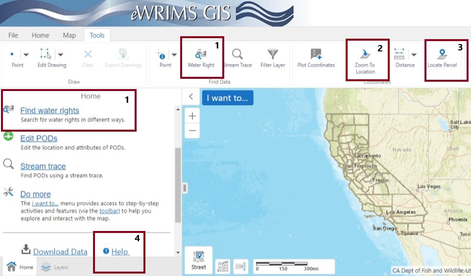
The eWRIMS Web Mapping Application provides the spatial location of water rights throughout California. Using a Geographic Information System (GIS), you can search for the location of water rights by visually displaying the location of point(s) of diversion on a map or aerial photograph. If you find water rights using this method, you can use the eWRIMS Database System (above) to search for information about the water rights.
Note: See the Data Dictionary and Definitions section of this guide to better understand search fields and terms.
App Anatomy Highlights
- Find Water Rights – Both allow you to search by various methods for water rights, as seen in the figure.
- Zoom to Location – Allows you to enter longitude and latitude coordinates and view any nearby water rights.
- Locate Parcel – Allows you to search by County and Assessor’s Parcel Number1 (APN).
- Help – Opens a User Guide (PDF) detailing various methods for searching for water rights and relevant information.
1 APN information may not be available within the mapping tool due to the availability of this data from external (i.e., county) sources.

Water Rights Progress Reports – Annual Water Use Report
About
The Water Rights Progress Report provides a monthly snapshot of work received and completed by the Division of Water Rights. The automated report is available for the previous month by the 10th day of the next month. The customizable report allows users to select a date range and type of report. The customizable report will allow users to export and download data into a CSV file.
Note: See the Data Dictionary and Definitions section of this guide to better understand search fields and terms.
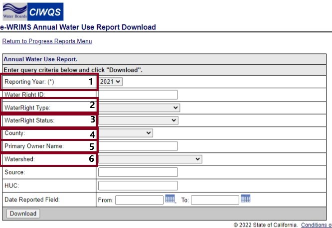
Annual Report Menu Anatomy Highlights
- Reporting Year
- Water Right Type
- Water Right Status
- County
- Primary Owner Name
- Watershed

Data Dictionary & Definitions
Data Dictionary
California Open Data Portal provides a data dictionary (e.g., detailed descriptions of what data is collected) for eWRIMS water right data.
Appendix A & B (of the Data Dictionary) Link
Definitions
| Term | Definition |
|---|---|
Term |
Definition |
Application ID / Permit ID / License ID |
A unique identifier provided when an application to divert water has been accepted (Application ID), permitted (Permit ID), licensed (License ID). |
County |
A political administrative division of California. |
HUC |
Watersheds are delineated by USGS using a nationwide system based on surface hydrologic features. A complete list of Hydrologic Unit codes, descriptions, names, and drainage areas can be found in the United States Geological Survey Water-Supply Paper 2294, entitled "Hydrologic Unit Maps". |
Primary Owner (Name) |
The primary owner on record with the Division of Water Rights. It is not possible to search by non-primary owners or agents. But it is possible to see all owner and agent information for a water right. |
Reporting Year |
The calendar year the water was diverted. |
Source |
Staff defined entry. |
Watershed |
Political definition. |
Water Right Type |
Water right type indicates the type of water record it is. Currently there are 18 different types of water right types to identify the water record. See appendix A for further details. |
Water Right Status |
Water right status identifies the current status of the water right type. There are multiple water right statuses for each water right type. See appendix B for further details. |
Common Searches
HOW DO I VIEW WATER RIGHTS IN A SPECIFIC COUNTY?
Water Rights Record Search
- Navigate to the eWRIMS Database System (Public Database)
- Click the "eWRIMS Database System" hyperlink
- Click the "Water Rights Records Search"
- Find the "County" search field
- Optional: Include figure 1 and the text (see the number 4 in the provided image)
- Select the specified county
- Search
Water Rights Web Mapping Application
- Navigate to the eWRIMS Database System (Public Database)
- Click the "eWRIMS Database System" hyperlink
- Click the "Water Rights Web Mapping Application" hyperlink
- Click the "Find Water Right" hyperlink
- Optional: Include figure 2 and the text (see the number 1 in the provided image)
- Click the "County" radial field
- Click "Search"
- Select the specified county
- Search
HOW DO I VIEW WATER RIGHTS IN A SPECIFIC WATERSHED?
Water Rights Record Search
- Navigate to the eWRIMS Database System (Public Database)
- Click the "eWRIMS Database System" hyperlink
- Click the "Water Rights Records Search"
- Find the "Watershed" search field
- Select the specified watershed
- Search
Water Rights Web Mapping Application
- Navigate to the eWRIMS Database System (Public Database)
- Click the “eWRIMS Database System” hyperlink
- Click the “Water Rights Web Mapping Application” hyperlink
- Review the “Search for Water Right by Watershed” section of the GIS User Guide
CAN I SEARCH FOR A SPECIFIC WATER RIGHT?
Water Rights Record Search
- Navigate to the eWRIMS Database System (Public Database)
- Click the "eWRIMS Database System" hyperlink
- Click the "Water Rights Records Search"
- Find the "Application ID" search field
- Optional: Include figure 1 and the text (see the number 3 in the provided image)
- Enter the specified water right
- Search
Water Rights Web Mapping Application
- Navigate to the eWRIMS Database System (Public Database)
- Click the "eWRIMS Database System" hyperlink
- Click the "Water Rights Web Mapping Application" hyperlink
- Click the "Find Water Right" hyperlink
- Optional: Include figure 2 and the text (see the number 1 in the provided image)
- Click the "ID" radial field
- Click "Search"
- Enter the specified water right
- Search
What Water Rights Does <Insert Name> Own?
Water Rights Record Search
- Navigate to the eWRIMS Database System (Public Database)
- Click the "eWRIMS Database System" hyperlink
- Click the "Water Rights Records Search"
- Find the "Primary Owner" search field
- Optional: Include figure 1 and the text (see the number 5 in the provided image)
- Select the specified county
- Search
Water Rights Web Mapping Application
- Navigate to the eWRIMS Database System (Public Database)
- Click the "eWRIMS Database System" hyperlink
- Click the "Water Rights Web Mapping Application" hyperlink
- Review the "Search for Water Right by Owner or Business Name" section of the GIS User Guide
Are There Water Rights Associated With a Specific Property?
Water Rights Web Mapping Application
- Navigate to the eWRIMS Database System (Public Database)
- Click the "eWRIMS Database System" hyperlink
- Click the "Water Rights Web Mapping Application" hyperlink
- Click the "Find Water Right" hyperlink
- Optional: Include figure 2 and the text (see the number 1 in the provided image)
- Click the "APN" radial field
- Click "Search"
- Enter the specified water right
- Search
Note: If the user doesn’t have an APN you could provide instructions for viewing specified GPS (i.e., Latitude and Longitude) coordinates or for browsing the GIS map.
Can I view water rights with GPS Coordinates?
Water Rights Web Mapping Application
- Navigate to the eWRIMS Database System (Public Database)
- Click the "eWRIMS Database System" hyperlink
- Click the "Water Rights Web Mapping Application" hyperlink
- Click the "Zoom to Location" button
- Optional: Include figure 2 and the text (see the number 3 in the provided image)
- Enter the specified Latitude and Longitude
- Click "Continue"
Can I Browse for Water Rights?
Water Rights Web Mapping Application
- Navigate to the eWRIMS Database System (Public Database)
- Click the "eWRIMS Database System" hyperlink
- Click the "Water Rights Web Mapping Application" hyperlink
- Review the "Pan/Zoom/Navigate Around the Map" section of the GIS User Guide
Is there a way to get water use data for entire areas?
Water Use Annual Reports
- Navigate to the eWRIMS Database System (Public Database)
- Click the "eWRIMS Database System" hyperlink
- Click on the "Water Rights Progress Report" hyperlink
- Click on the "Annual Water Use Report" hyperlink
- Use this menu to search based on information need, the result will be an Excel file of water use data
- Optional: Include figure 3 and the text (see image for menu layout)
HOW DO I VIEW WATER RIGHT DOCUMENTS AND MAPS FOR SPECIFIC RECORDS?
Water Rights Record Search
- Navigate to the eWRIMS Database System (Public Database)
- Click the "eWRIMS Database System" hyperlink
- Click the "Water Rights Records Search"
- Find the "Application ID" search field
- Enter the specified water right
- Search
- Click the application number on the left side of the results
- Click "View Document" to see the documentation file
- Click "View Map" to see the map file
- If the file is not available, please contact our Records Room at dwr@waterboards.ca.gov or (916) 341-5300.


