Watershed Assessment and Recovery Unit
Announcements
The North Coast Water Board is excited to introduce the new Watershed Assessment and Recovery Unit (WARU). The WARU team’s initial focus is on the development and implementation of a permit that addresses sediment pollution from private, rural roads in the Gualala River watershed, referred to as the Gualala Roads Permit.
Follow the link below for a flyer providing key information about the Gualala Roads Permit.
Gualala Roads Permit Flyer
WARU staff will begin outreach and engagement with landowners and community members in spring 2025. To learn more about the permit to be developed and opportunities to engage in the development process, please contact the WARU staff listed in the “Contact” section to the right and subscribe to our email list (see “Stay Informed” section).
Quarterly project status updates
Watershed Assessment and Recovery Unit Overview
Around 61% of streams and rivers in the North Coast Region are impacted by high amounts of sediment. The greatest contributor to sediment pollution in the North Coast Region is unpaved, rural roads. The North Coast Water Board regulates various activities that involve road work, such as timber harvest, construction, cannabis cultivation, and more, but until recently has not had a program focused exclusively on repairing rural road conditions to improve water quality throughout the North Coast Region.
In 2001, the U.S. Environmental Protection Agency (EPA) set limits on sediment for the Gualala River watershed to protect its health. The North Coast Water Board has been working to meet these limits using its Sediment TMDL Implementation Policy. In 2023, the North Coast Water Board requested funding to create a unit to address sediment and temperature issues in the Gualala River and other watersheds. The State Water Resources Control Board approved the request for the new unit, leading to the creation of the Watershed Assessment and Restoration Unit (WARU) in fall 2024. The purpose of the WARU is to support the recovery of sediment and temperature impaired watershed in the North Coast Region through the lens of addressing sediment pollution from rural roads.
The WARU’s initial focus is the development of a permit to reduce sediment pollution from rural roads in the Gualala River Watershed (see Gualala Roads Permit FAQs below). WARU staff also oversee other permits that apply to discharges from rural roads, including the Rural Roads General Order and Five Counties (5C) Waiver.- The Gualala River Watershed is identified as “impaired” under Section 303(d) of the Clean Water Act due to high sediment amounts and elevated water temperatures. Excess sediment in the Gualala River Watershed in part negatively affects the migration, spawning, reproduction, and early development of cold-water fish, such as native salmon and trout, and increases water temperatures.
- All landowners in the watershed will be required to maintain their roads to minimize and prevent erosion and sediment discharges to waterbodies.
- Landowners above a certain threshold, such as 1,000 acres or more, and landowners who own roads that are identified as posing a significant risk to water quality, will be required to adhere to additional permit requirements such as those outlined below. These landowners will be referred to as Designated Landowners.
- Designated Landowners will be required to reduce sediment sources on their roads in part by hydrologically disconnecting road segments from waterbodies and upgrading or replacing stream crossings where necessary. Hydrologically disconnecting roads from streams involves installing or maintaining drainage features to prevent water runoff from flowing directly from the road surface into nearby waterways. Upgrading stream crossings involves improving structures like bridges and culverts to ensure that they allow water to flow naturally while minimizing and preventing erosion and impacts to aquatic species. (See Road Improvement Fundamentals below.)
To accomplish this, the permit will require Designated Landowners to:
- Inventory (e.g., identify the number of stream crossings or road mileage), assess (e.g., determine the conditions of those roads and stream crossings), prioritize (e.g., identify which roads or stream crossings should be fixed first), and fix sediment sources on their roads;
- Track and report on progress and effectiveness of fixes; and
- Maintain roads to preserve fixes and prevent and minimize erosion and sediment delivery to waterbodies; and
- Adhere to an implementation schedule for road fixes.
- Permit fees (e.g., upon enrollment and/or annually)
- Road assessments, fixes, and maintenance – Costs vary depending on site-specific factors such as geology, topography, road conditions and density, and other considerations. Qualified professionals should be consulted on ownership-specific costs of road assessments and fixes.
- The North Coast Water Board is funding the inventory, assessment, and prioritization of certain high priority roads in the watershed and hold training for landowners to provide information on road drainage concepts and how to implement road fixes themselves.
- Federal and state grants and technical assistance.
- North Coast Water Board staff are available to answer questions regarding road improvement-related grants and other funding opportunities.
- Long-term cost savings – Preventive maintenance, such as addressing drainage and stream crossing issues early, avoids costly repairs from erosion, gullies, or structural damage.
- Fisheries recovery and protection – Sedimentation from road runoff degrades habitats for fish and other aquatic species. Mitigating runoff increases the survival of threatened and endangered salmon and trout.
- Water sources protection – Road runoff contaminated with sediment can degrade drinking water supplies. Proper drainage protects groundwater and surface water used for irrigation and domestic needs.
- Attend future community meetings and workshops on permit concepts
- Schedule in-person or virtual meetings with North Coast Water Board staff
- Provide comment on draft permit documents when available
- Sign up for the email subscription list on the right-hand side of the page.
- setting water quality standards for waterbodies;
- developing and issuing permits to regulate sources of pollution;
- monitoring and analyzing the health of waterbodies; and
- enforcing environmental regulations.
- All stream crossings have a drainage structure designed for the 100-year flood flow (including woody debris and sediment).
- Stream crossings have no diversion potential (functional critical dips are in place).
- Culvert inlets have low plug potential (trash barriers or deflectors are installed where needed).
- Culverts are installed at the base of the fill and in line with the natural channel.
- Any existing culverts or new emergency overflow culverts that emerge higher in the fill have full round, anchored downspouts that extend to the natural channel.
- Stream crossing culvert outlets are protected from erosion (extend culverts at least 6 feet beyond the base of the fill and use energy dissipation, where needed).
- Culvert inlet, outlet and bottom are open and in sound condition.
- Deep fills (deeper than a backhoe can reach from the roadbed) with undersized culverts or culverts with high plugging potential are fitted with an emergency overflow culvert.
- Bridges have stable, non-eroding abutments and do not significantly restrict 100-year flood flow.
- Stream crossing fills are stable (unstable fills are removed or stabilized).
- Approaching road surfaces and ditches are “disconnected” from streams and stream crossing culverts to the maximum extent feasible using road shaping and road drainage structures.
- Class I (fish-bearing) stream crossings meet State Fish and Wildlife and National Marine Fisheries Service fish passage criteria.
- Decommissioned stream crossings are excavated to exhume the original, stable, stream bed and channel sideslopes, and then stabilized with mulch and vegetation.
- Unstable and potentially unstable road and landing fills that could deliver sediment to a stream are excavated (removed) or structurally stabilized.
- Excavated spoil is placed in locations where eroded material will not enter a stream.
- Excavated spoil is placed where it will not cause a slope failure or landslide.
- Road surfaces and ditches are hydrologically “disconnected” from streams and stream crossing culverts. Road surface runoff is dispersed, rather than collected and concentrated.
- Ditches are drained frequently by functional ditch relief culverts, rolling dips or cross road drains.
- Outflow from ditch relief culverts does not discharge to streams.
- Ditch relief culverts with gullies that deliver to a stream are removed or dewatered.
- Ditches and road surface drainage does not discharge (through culverts, rolling dips or other cross drains) onto active or potential landslides.
- Decommissioned roads have permanent drainage and do not rely on ditches.
- Fine sediment contributions from roads, cutbanks and ditches are minimized by utilizing seasonal closures and installing a variety of surface drainage techniques including berm removal, road surface shaping (outsloping, insloping or crowning), rolling dips, ditch relief culverts, waterbars and other measures to disperse road surface runoff and reduce or eliminate sediment delivery to the stream.
Gualala Roads Permit Development
The North Coast Water Board is developing a new water quality permit that will affect landowners in the Gualala River Watershed. This permit aims to address high amounts of sediment and high water temperatures that are harming the river's ecosystem, particularly its native salmon and trout populations. This permit is in the early stages of development, and the North Coast Water Board is committed to engaging the public throughout this process. Landowners and community members will have multiple opportunities to provide input and inform the final permit requirements as highlighted in the graphic below.

Why is a roads permit in the Gualala River watershed necessary?
Who will this permit apply to?
What will permit requirements for Designated Landowners include?
What are the anticipated types of associated costs for Designated Landowners?
What funding sources or assistance are available?
What are the benefits of improved roads?
How can I provide input in this process
What is the timeline for the development of the permit?
Summer 2025 – In-person and/or virtual meetings to solicit input on the environmental analysis document under development to support the permit.
Summer 2026 – Review and comment on the draft permit and environmental analysis document and public workshop.
Fall 2026 – Proposed adoption hearing for the permit and supporting environmental analysis document.
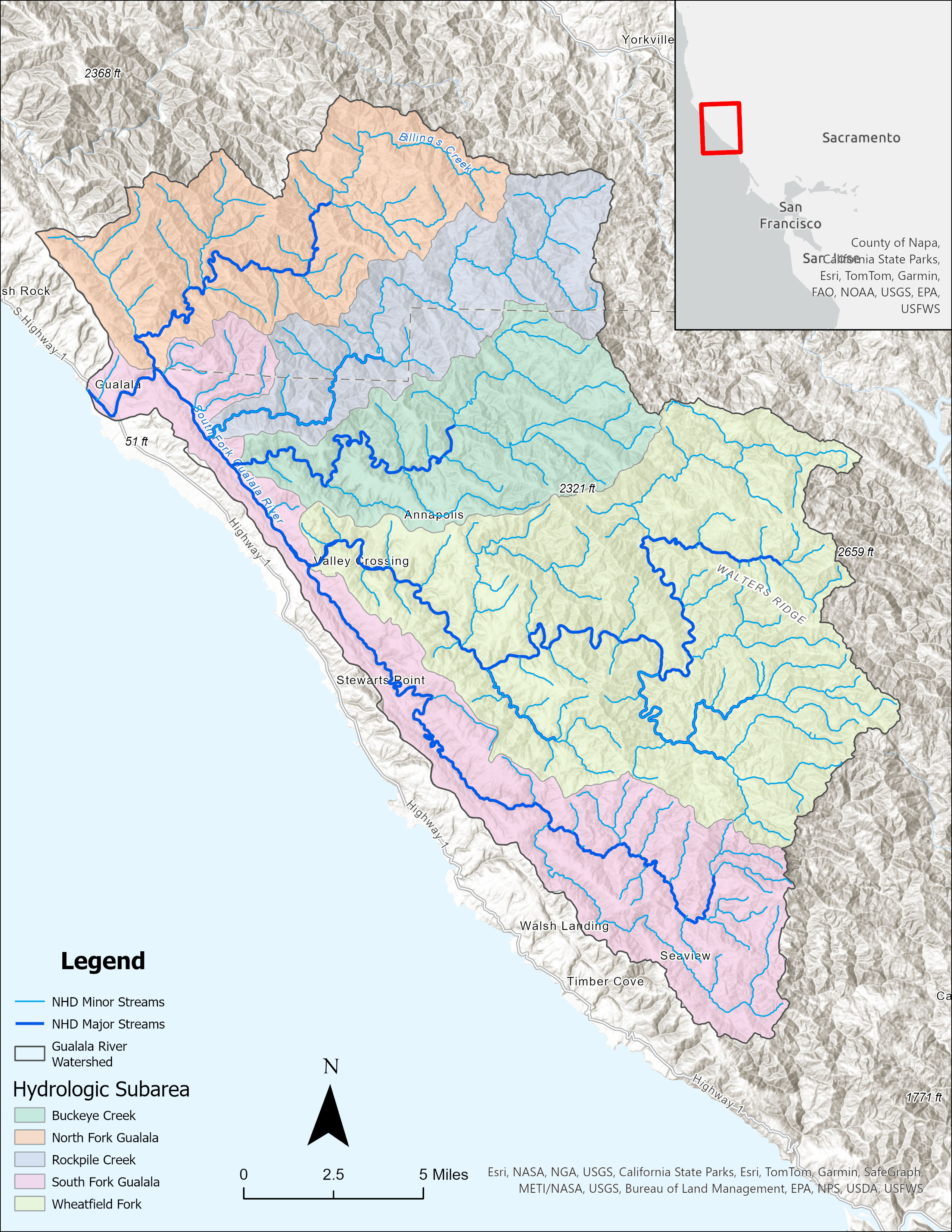
Gualala River Watershed Overview
The Gualala River Watershed spans about 300 square miles across Sonoma and Mendocino counties. Its unique elongated shape, influenced by the San Andreas and Tombs Creek faults, supports a diverse ecosystem with forests of redwood and Douglas-fir, and various beneficial uses of water, such as cold water fisheries, recreation, and drinking water. The Gualala River is considered "impaired" under the Clean Water Act due to too much sediment in the water and elevated water temperatures. These conditions are negatively impacting fish like native salmon and trout, affecting their migration, spawning, and early development. Approximately 61% of the sediment entering streams in the Gualala River watershed is from rural roads, which span a length of more than 1,500 miles. To improve the watershed’s health, the amount of sediment coming from these roads must be reduced by almost 90%.
North Coast Water Board’s Role in Protecting the Watershed
What is the North Coast Water Board’s role in protecting the watershed?
The North Coast Regional Water Quality Control Board, or North Coast Water Board, is the primary California state agency responsible for protecting and improving water quality in streams, rivers, lakes, wetlands, and groundwater in the North Coast. This involves:
A Total Maximum Daily Load – a regulatory tool that identifies the amount of a contaminant (e.g., sediment) that a waterbody can receive and still properly function – was developed in 2001 and identifies roads as one of the key sediment sources in the watershed. Part of the Total Maximum Daily Load implementation strategy for the watershed is developing 1) an Action Plan that describes how the Total Maximum Daily Load will be achieved and 2) a permit that requires landowners to reduce the amount of sediment on rural, private roads that can enter waterbodies.
The forthcoming Gualala Roads Permit will be one of several permits that the North Coast Water Board administers in the watershed to prevent and minimize water pollution from land use activities. Other existing water quality permits regulate activities such as forestry management and timber harvest, cannabis cultivation, construction sites and industrial facilities, and may soon include commercial vineyards.Road Improvement Fundamentals
A critical element of controlling sediment discharges from roads is to apply storm-proofing treatments. In their Updated Handbook for Forest, Ranch, and Rural Roads, Pacific Watershed Associates have prepared a list of storm-proofed roads characteristics. That list is reproduced below.
Storm-proofed Stream Crossings:
Storm-proofed Road and Landing Fills:
Storm-proofed Road Surface Drainage:
Stay Informed
Interested parties who would like to receive notifications of Gualala Roads Permit project updates can enroll in email list subscriptions – select “Gualala River Watershed - TMDL” from the options provided.
Contact
Devon Rabellino at R1-Gualala@waterboards.ca.gov
