
Supply and Demand Assessment (SDA) Information
Overview
From 2020 to 2023, in response to drought conditions, the State Water Board adopted emergency regulations and developed tools and information to further understand water availability in key watersheds. The Water Board's drought effort highlighted the need for specialized tools that can be used to evaluate water supply and demand and support broader water management. The Division of Water Rights, Supply and Demand Assessment Unit (SDA) was established in 2022 to develop water supply models and refine water demand data for select watersheds throughout California. The SDA Unit will focus on the following objectives:
- Development of water supply (or hydrologic) models that assess surface water availability in select watersheds.
- Refinement of water use data, including evaluation of the annual water use data reporting submitted by water right holders each year, that will be used to assess water demand in different water years.
- Advancement of water allocation tools used to evaluate how various water use scenarios impact water supply in a given watershed.
All tools developed under this effort will be open-source and publicly available to support both local and Board efforts. This information can be used by interested parties to inform water management options and local solutions within a watershed. This work will provide the Board with additional resources to protect water availability in accordance with water right priority and public trust resources.
Announcements
The State Water Board’s Supply and Demand Assessment Program invites the public to attend a LSPC (Loading Simulation Program in C++) model demonstration. Our Program is developing LSPC water supply models for 17 watersheds in California. The demonstration is targeted at individuals who may want to use the finalized watershed models to study additional scenarios or projects. This model demonstration will show how to set up and run the LSPC model, interpret the results, and explain the calibration and validation process. While the demonstration is focused on technical elements of LSPC modeling, the first portion of the demonstration aims to provide background on the Supply and Demand Assessment Program that may be of interest more broadly. The Navarro River model has been completed, and staff will use the Navarro River LSPC model as an example for the demonstration.
- Instructional LSPC Watershed Model Demonstration Date: Tuesday, January 27th
- Time: 10am to 12pm 10am to 12pm
- Where: Zoom, registration required.
The format of the session will be a series of technical demonstrations in simple language with question and answer (Q&A) sessions.
Outreach and Engagement
Spring 2024 Public Meetings on the Selection of Project Watersheds
- Notice of Public Meeting
- Public Meeting Recording
- Public Meeting Presentation Slides
- SDA Fact Sheet on Water Supply and Demand Assessments
California Water and Environmental Modeling Forum - 2024 Annual Meeting
Program Watersheds
- Big Creek
- Butte Creek
- Gualala River
- Mattole River
- Napa River
- Navarro River
- Pescadero Creek
- Petaluma River
- Pismo and San Luis Obispo Creeks
- Putah Creek
- Russian River
- Salmon Creek
- San Gregorio Creek
- San Lorenzo River
- Santa Maria River
- Sonoma Creek
- Tomales-Drakes Bay
- Trinity River
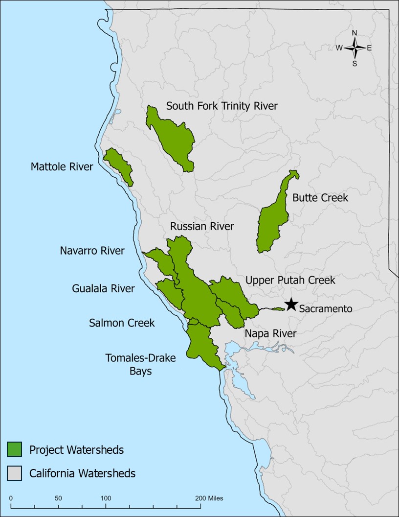
- Click on Map to Enlarge
Demand Methodology
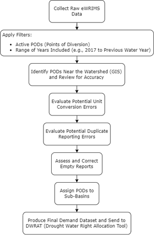
Every water year, water right holders are required to self-report how much water they used and diverted each month. This data is stored on the Division of Water Rights’ California Water Accounting, Tracking, and Reporting System (CalWATRS) and can represent the demand for surface water diversions for any watershed of interest. We assign the monthly diversion volumes to sub-basins of a given watershed based on the location of the water right’s points of diversion (PODs). We then map the hydrologic connectivity between sub-basins, tributaries, and rivers within the same watershed.
The SDA Unit averages all available self-reported annual water usage and diversion data from water year 2017 onwards to the most recent water year whose submission deadline has passed to estimate monthly mean demands for each sub-basin. Then, we use this estimate along with water supply availability data as inputs to run the Drought Water Right Allocation Tool (DWRAT). DWRAT then provides monthly water allocation estimates at a sub-basin scale.
Because self-reported annual water usage and diversion data contain many errors, they do not perfectly represent demand and cannot be used as a direct demand input into DWRAT. A comprehensive Quality Assurance and Quality Control (QAQC) procedure corrects the raw reporting data in order to generate a reliable demand dataset. This procedure consists of the following steps:
- Filter to active consumptive water rights and claims
- Geospatial Analysis of PODs
- Unit Conversion Errors Review
- Duplicate Reporting Errors Review
- Empty Reports Review
- Sub-Basin Assignment
Filter to Active Water Rights and Claims
We do not include all water rights and claims available on CalWATRS in our analysis. We filter to the dataset to include only active points of diversion (PODs). Many water rights are inactive, rejected, revoked, pending, cancelled, or have some other non-active status—we exclude all such rights from our analysis. Additionally, we also do not include certain water right types. For example, we exclude rights that divert water for power generation because these rights are non-consumptive, and the water is likely to be accounted for by other rights. Groundwater recordations are also excluded because they apply only to 4 counties in Southern California and our methodology applies only to surface water.
Geospatial Analysis of PODs
We use geospatial analysis to identify water rights that likely have PODs within the watershed of interest. We review the POD locations as specified in CalWATRS and the associated water right documentation to verify the accuracy of the PODs’ geographic coordinates (PODs are occasionally plotted incorrectly in CalWATRS).
Unit Conversion Errors Review
Self-reported data may contain diversion volumes in the wrong units. For example, the diverter may provided values in gallons and mislabel the units as acre-feet. R scripts compare annual totals from each report to an established value for each water right (for example: the maximum possible volume or the median annual total). A report is flagged if its total diversion volume is significantly different from the established value, and we manually review these submissions and their associated water rights to assess whether an error occurred.
Duplicate Reporting Errors Review
Some parties divert using multiple water rights. When submitting reports, they may specify the exact same monthly volumes across multiple water rights. If they are simply splitting their total usage across these reports, there is no issue. But if they are repeating their total usage in each report, this is a duplicate reporting error which must be corrected to prevent overestimate of their diversions. Our scripts flag submissions for different water rights that have the same combination of owner, annual diversion total, and reporting year as potential duplicates. We then examine these water rights and their documentation to determine whether a duplicate reporting error is present.
Empty Reports Review
Very rarely, we have encountered submissions that have an annual total diversion amount specified, but they are missing monthly volumes. So far, this issue has only been observed in reports that had no diversions in a reporting year (i.e., all volumes would be zero), and the annual diversion total is reported as zero, while monthly diversions are left blank. The QAQC procedure ignores missing volumes when determining a water right’s average withdrawals, but zeroes can (and should) affect these calculations. To ensure that these submissions are properly included in the dataset, we check these reports and complete the missing monthly entries with zeroes.
Sub-Basin Assignment
Based on the locations of a water rights’ PODs, we assign its average diversion data to a corresponding sub-bsin in the watershed. If a water right has multiple PODs, and they are located in multiple sub-basins, adjustments are needed. Diversion data is reported by water right rather than by POD, so a single sub-basin represents the water rights’ diversion source in DWRAT to avoid assumptions about a water right’s usage of each individual POD. If the sub-basins are connected (i.e., flow from one sub-basin eventually reaches the other sub-basin), the water right’s diversion data is assigned to the most downstream sub-basin. If the sub-basins are not connected, we split the water right into sub-rights, and we proportion its diversion data among the sub-rights based on the sub-basins’ drainage areas.
- DWRAT_DataScraping Demand GitHub Repository
This public GitHub repository contains all the demand R language scripts used by the SDA Demand Methodology. - SDA Detailed Demand Dataset Procedure
These are the main detailed step-by-step instructions that explain how to use the R scripts to replicate the SDA Demand Methodology for a water rights demand dataset. This procedure document is the public version, which is accurate as of 5/8/2025. However, the SDA Unit is always updating its processes, so keep in mind, this version may be outdated when you refer to it. For the latest updates, or if you encounter errors, please contact us at DWR-SDA@waterboards.ca.gov. - SDA GIS Full Manual Review Methodology
This is a sub-procedure that explains all the manual steps of the GIS review process and supplements the main demand dataset procedure document. This procedure document is the public version, which is accurate as of 5/8/2025. However, the SDA Unit is always updating its processes, so keep in mind, this version may be outdated when you refer to it. For the latest updates, or if you encounter errors, please contact us at DWR-SDA@waterboards.ca.gov. - SDA Demand Methodology Walkthrough for Division of Water Rights Presentation
This PowerPoint is a detailed visual walkthrough of the SDA Demand Walkthrough that SDA Unit staff presented to the Division of Water Rights on 3/13/2025. - SDA Demand Methodology Walkthrough for Division of Water Rights Recording
This file is a video recording of the SDA Demand Walkthrough that SDA Unit staff presented to the Division of Water Rights on 3/13/2025.
LSPC Watershed Model Demonstration
The following recordings guide you through the LSPC modeling process, starting with an overview of the SDA Program and how the model works, then stepping through setup, calibration, interpreting your results, and the many applications of LSPC.
- Part 1 - Introduction and Overview
- Part 2 - Running the Model
- Part 3 - Calibration and Validation
- Part 4 - Interpreting Model Results Payman
- Part 4a - Saving Instances of the Model Payman
- Part 4b - Altering Model Outputs
- Part 4c - Adjusting Model Parameters editing the Land Use Codes
- Part 4d - Adjusting Model Parameters
- Part 4e - Adjusting Model Parameters editing the Infiltration Index
- Part 4f - Adjusting Model Parameters Specifying Temporal Settings
- Part 5 - Model Applications
- Part 6 - LSPC Model Q & A
Additional Resources
Stay Informed
Email Subscription List
Subscribe to the SDA Information email topic to receive notifications and the latest updates.
Contact Us
If you have questions or please email them to: DWR-SDA@waterboards.ca.gov
