
Supply and Demand Assessment (SDA) – Santa Maria River
Overview
The Santa Maria and Cuyama Rivers Watershed is a major coastal basin on California’s Central Coast, draining approximately 1,828 square miles. The watershed includes the Santa Maria River, a largely free-flowing system fed by 19 principal tributaries, including the Sisquoc River, Tebusquet Creek, Orcutt Creek, La Brea Creek, and Manzana Creek. From the confluence of the Sisquoc and Cuyama Rivers, the Santa Maria River flows west through the City of Santa Maria before reaching the Pacific Ocean. The elevation range of the watershed extends from sea level near the outlet to over 2,600 meters (8,500 feet) in the eastern highlands near the Los Padres National Forest. The region’s Mediterranean climate features wet winters and dry summers, with an average annual precipitation of about 14 inches. Land cover is dominated by shrub/scrub (55%) and grassland/herbaceous (22%) vegetation, with additional areas of cultivated crops (5%), evergreen forest (6%), mixed forest (5%), and developed lands (4%).
The watershed provides important habitat for both resident rainbow trout and anadromous steelhead. The Sisquoc River is a key spawning and rearing tributary for steelhead and joins the flow-regulated Cuyama River in the northern portion of the basin. Twitchell Dam, located on the Cuyama River, is operated primarily for groundwater recharge and flood control, which significantly limits surface flows through the Santa Maria River—flows that are critical for steelhead migration between the ocean and upstream habitats. Although the Santa Maria River is naturally intermittent, dam operations have further reduced the frequency and duration of fish-passable flows. In a recent U.S. Supreme Court decision, operations at Twitchell Dam were determined to be subject to the Endangered Species Act, requiring that dam management ensure protection of the endangered steelhead population.
In addition to hydrologic barriers, the Santa Maria River is listed as impaired by several pollutants, including metals, pesticides, nutrients, toxicity, and pathogens. These impairments are primarily attributed to agricultural and urban runoff, as well as stormwater discharges.
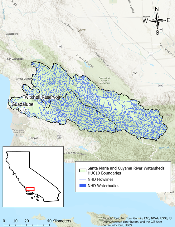
- Click on Map to Enlarge
Announcements
February 27, 2026 - Santa Maria River Watershed Model Work Plan - Now Available
The work plan from Paradigm Environmental for development of a hydrologic model for the Santa Maria River watershed is now publicly available in Model Development section below. Please email questions regarding the model development to DWR-SDA@waterboards.ca.gov.
Model Development
Outreach and Engagement
- Santa Maria River Watershed Fact Sheet Coming Soon
Modeling in the Santa Maria and Cuyama Rivers
The SDA Unit has continued to work on the models and tools developed for the Russian River Watershed during the State Water Board's 2021-2022 Regional Drought Response. These tools provided the necessary information for the Division of Water Rights (Division) to assess water availability and issue water right curtailments to ensure adequate, minimal water supplies for critical purposes under the emergency regulation.
To capture the water demand in the SDA Program Watersheds, water right demand estimates were incorporated based on information from annual reports of water diversion and use submitted to the Division. The SDA Unit continued to develop the Division’s demand dataset methodology and converted it into a series of R scripts and manual review spreadsheets that apply data quality correction flags. For example, the scripts identified and corrected unit conversion errors, duplicate reporting, and misplotted points of diversion. The SDA Unit then uses a water allocation tool adopted from the UC Davis Drought Water Rights Allocation Tool (DWRAT) to allocate available supply amongst water right holders based on their respective water right priority and water demands. This version of DWRAT allocates water at the subbasin level and accounts for imported flows.
The SDA Unit’s demand methodology, along with the supply scripts and the watershed specific versions of DWRAT, will be made available on the California Water Board Data Center GitHub page as separate repositories.
Supply and Demand Assessment Program Links
Supply and Demand Assessment Information
Project Watersheds:
Stay Informed
Email Subscription List
Subscribe to the SDA Information email topic to receive notifications and the latest updates.
Contact Us
If you have questions or please email them to: DWR-SDA@waterboards.ca.gov
