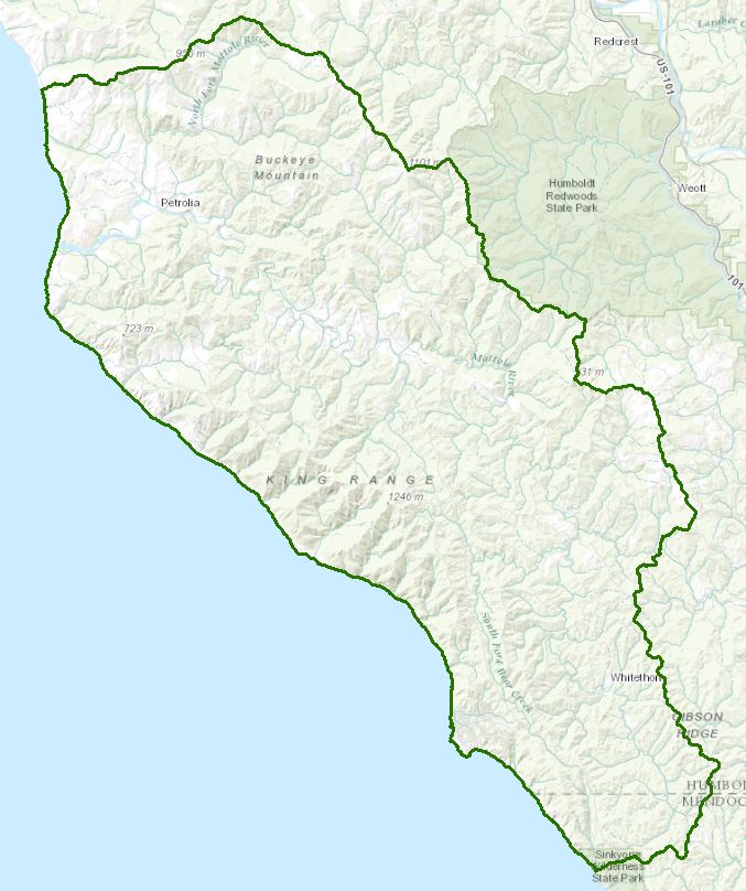
Mattole River Watershed – HA 112.30
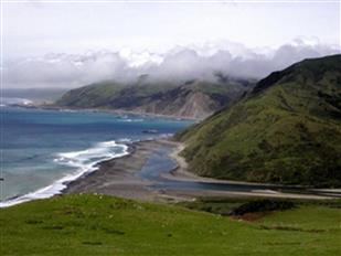
Mattole River estuary
(Mattole Restoration Council - Mattole, CC BY-SA 3.0,
https://commons.wikimedia.org/w/index.php?curid=10970772
(Mattole Restoration Council - Mattole, CC BY-SA 3.0,
https://commons.wikimedia.org/w/index.php?curid=10970772
The Mattole River watershed drains about 304 square miles bonded by the Bear River watershed to the north, the Eel River to the east, and King Range to the west. A portion of the hydrologic area is not in the Mattole River watershed, per se, rather includes the small coast streams of the King Range. The Mattole River watershed ranges from about 4,000 feet in elevation to sea level. Plant associations include coastal redwood forest in the southern headwaters and mixed Douglas fir/hardwood forest in the remainder, interspersed with areas of mixed chaparral and grasslands. Primary uses include recreation, agriculture, and domestic and industrial water supply. Its cold freshwater habitat is home to three anadromous salmonid species: Chinook and coho salmon, and steelhead. They are all listed as threatened under the Federal Endangered Species Act.
Water Quality, Flow, and Water Rights
2012 Water Quality Assessment Report
Every six years the North Coast Water Board evaluates water quality information and identifies water bodies that do not meet water quality standards and are not supporting their beneficial uses. Those waters are placed on a list of impaired water bodies that identifies the pollutant or stressor causing impairment and establishes a schedule for developing a control plan to address the impairment.
Impaired Water Bodies in the Mattole River Hydrologic Area |
||
Water Body Name |
Listing Extent |
Pollutant |
Mattole River HA, |
Entire water body |
Sedimentation / Siltation Temperature |
Main program page:
Map of water quality listed segments. (Click on the map tab)
2013 Sediment TMDL Report Card
2008 North Coast Water Board's Sediment TMDL Implementation Workplan
The Regional Water Board adopted a TMDL implementation policy statement in 2004 and a subsequent Workplan in 2008 that details efforts to address sediment impaired water bodies in the region. The section on the Mattole River watershed begins on page 149.
2002 Mattole River Sediment TMDL
The Regional Water Board prepared a Technical Support Document (TSD) that addressed sources of sediment and temperature impairments, loading capacities, and load allocations necessary to restore sediment and temperature conditions supportive of beneficial uses related to the cold water fishery in the Mattole River Watershed. That TSD served as the basis for U.S. Environmental Protection Agency (USEPA) sediment and temperature TMDLs, established in 2002.
Water Rights Database
Statements of water diversion and use, registrations, certificates and water rights permits are accessible on the eWRIMS, electronic Water Rights Information Management System. This link includes a mapping application.
California Data Exchange Center
This California Department of Water Resources site provides flow and stage data for two locations in the Mattole River watershed:
Near Petrolia (lower watershed)
Near Ettersberg (upper watershed)
and weather information (temperature, rainfall, wind speed and direction)
Honeydew (middle watershed)
Cooksie Mountain (lower watershed near coast)
California Environmental Data Exchange Network
Water quality and habitat data and information are contained at this site in a spreadsheet format. Pay careful attention to the instructions.
Landscape Information
2005 N. Coast Water Board Watershed Initiative Chapter, Russian/Bodega WMA
The North Coast Region developed a Watershed Initiative Chapter as part of the State Water Board's Watershed Management Initiative that provides an overview of that watershed, a description of its water quality concerns and issues, past significant Regional Board activities in the watershed, activities as of 2005, near-term activities that would benefit the watershed, and activities which may happen on a longer time-scale.
North Coast rivers
California Geographic Information Portal
This portal has a search engine for the portal itself and ArcGIS online. Information and GIS layers can be accessed for a variety of data, including hillshade, vegetation, rivers, contours, stream fish habitat by reach, stream inventory reports, and CalWater 2.2 maps.
http://portal.gis.ca.gov/geoportal/catalog/main/home.page
CalFire Fire and Resource Assessment Program
This site contains a wealth of information on the amount and extent of forest and rangelands along with analysis of conditions. Maps, projects, and assessments are available on the site, including GIS layers for timber harvesting, vegetation, and other resources.
U.S. Natural Resources Conservation Service Geospatial Data Gateway
Environmental and natural resources GIS files are available at this site, along with an interactive national map viewer.
Watershed Condition Information
North Coast Watershed Assessment Program
This multi-agency program began in 1999 and was defunded in 2002 due to state budget cuts. It was a five-agency effort to gather historical and current information on selected North Coast watersheds, assess the information, draw conclusions regarding trends and current watershed conditions, and provide recommendations for land use, restoration, and study in the future. Participating agencies included the Department of Fish and Wildlife (formerly Dept. of Fish and Game), CalFire (formerly California Department of Forestry, California Geological Survey (formerly Division of Mines and Geology), Department of Water Resources, and North Coast Regional Water Quality Control Board.
Reports from that effort are on a California Department of Fish and Wildlife website. The CDFW has continued to gather and assess information on North Coast watersheds since the statewide program was eliminated. The link to the CDFW website provides the assessment report. CDs of the report and appendices, including ArcInfo shape files can be obtained by contacting the California Department of Fish and Wildlife, Wildlife and Habitat Data Analysis Branch, 1807 13th Street, Suite 202, Sacramento, CA 95814 (916) 324-9265.
Assessment Report
Implementation Summary Compiled From the Assessment Report
Critical Coastal Areas
This program is administered by the California Coastal Commission and State Water Resources Control Board to foster collaboration on addressing issues associated with polluted runoff in critical coastal areas.
California EcoAtlas
This website provides access to information on wetlands, including integration of some water quality information.
Watershed Groups, Partnerships, and Collaboration
Mattole Restoration Council
This community-led nonprofit group was established in 1983 to address restoration and conservation of natural resources in the Mattole River watershed. The group developed an integrated watershed plan in 2009, a coho salmon recovery strategy in 2011, and a strategic plan in 2014 and holds regular community workshops on watershed issues.
Mattole Salmon Group
This group was formed in 1980 by residents to improve and restore native salmon in the Mattole River watershed. In addition to presentations of various projects, this website contains fishery and habitat data from the mid-1990s to 2014.
Sanctuary Forest
The Sanctuary Forest is a land trust with stream flow monitoring, watershed stewardship, land conservation, and education and outreach programs in the Mattole River watershed.
Inter Tribal Sinkyone Wilderness Council
The Council is comprised of ten individual tribes in the North Coast that owns and manages a 3845-acre redwood forest on the Lost Coast area.
Salmonid Restoration Federation
This nonprofit group was formed in 1986 to assist salmonid restoration efforts in California by promoting "restoration, stewardship, and recovery of California native salmon, steelhead and trout populations through education, collaboration, and advocacy." Their web site contains a wealth of information on salmonids and habitat and stream restoration in California.
California Watershed Network
This nonprofit organization was formed in 2000 to help protect and restore watersheds in California through community-based networks. The website contains some information on watershed events and older information on watersheds of interest, but most of it has not been updated since 2011.
UC Davis Information Center for the Environment, Natural Resource Project Inventory
This database provides information on natural resource projects in California, including links to data and information collected by the projects.
Fisheries and Wildlife Information
Mattole Salmon Group and Mattole Restoration Council
Both of these organizations (links in the above section) have a wealth of information on anadromous fish species in the Mattole River watershed.
Marine Protected Areas
The Mattole River drains into the Mattole Canyon State Marine Reserve, administered by the California Department of Fish and Wildlife.
CA Dept Fish and Wildlife Stream Inventory Reports
This California DFW site allows searches by major watershed areas (search on Mattole).
National Oceanic and Atmospheric Administration
NOAA Fisheries is responsible for listing and recovery efforts for anadromous fishes. The recovery plans for coho salmon and steelhead contain information on the habitat, population status, stressors and threats, recovery efforts, and recovery strategy (includes the Mattole River).
Coho salmon
Steelhead trout
CalFish Cooperative Anadromous Fish and Habitat Data Program
This cooperative agency site provides information on anadromous fish habitat and populations in an interactive environment. The site has numerous links to information libraries and systems in California.
The Nature Conservancy's "California Salmon Snapshots"
This website contains information on salmon populations and resources in California. This link provides information on the Mattole River watershed.
Klamath Resource Information System
This system was originally developed as a data repository and analysis and management tool for the Klamath River watershed. A host of information is available through this site, including maps, water quality data, fisheries data, photographs, and scientific references.
The links and information on this page are provided in an attempt to make a broad range of information available on a watershed basis. While the Water Board has been involved in work within watersheds with a variety of agencies and watershed groups, we cannot vouch for the currency or accuracy of information contained within the internet links we have included. We suggest that you check with the original sources if there is any question regarding currency, accuracy, or origin of information.
Created March 1, 2016
Web page contact : Robert Klamt, rklamt@waterboards.ca.gov
(Page last updated 10/16/17)
Water is a precious resource in California, and maintaining its quality is of utmost importance to safeguard the health of the public and the environment.
Statewide Campaigns
EPA Water Sense
File an Environmental Complaint
Save Our Water
Flex Alert
Register to Vote
