Laguna de Santa Rosa - Hydrologic Sub-areas 114.21, 114.22, 114.23
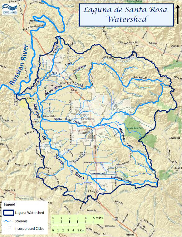
The Laguna de Santa Rosa is a major tributary of the Russian River and drains a 254 square mile watershed in Sonoma County, California. Major tributaries to the Laguna de Santa Rosa include Windsor Creek, Mark West Creek, Santa Rosa Creek, Blucher Creek, and Copeland Creek.
The Laguna de Santa Rosa Foundation's website has a good description of the system:
"The Laguna's 22-mile channel extends from Cotati to its confluence with the [Russian] River at Forestville, but the Laguna is far more than its main channel. It is a unique ecological system covering more than 30,000 acres and comprised of a mosaic of creeks, open water, perennial marshes, seasonal wetlands, riparian forests, oak woodlands and grasslands.
The Laguna is an important stopover for thousands of birds migrating along the Pacific Flyway and is home to a wide variety of life: more than 200 species of birds ranging from bald eagles to hummingbirds, rare and endangered salmon, steelhead, salamanders and plants, mountain lion, bobcat, coyote, mink, badger, and river otter.
In addition to the habitat it provides for wildlife, the Laguna is used for agricultural, recreational and educational purposes. It serves as a natural holding basin during our wet season and as an overflow area for the Russian River during floods, slowing and capturing floodwaters and easing their impact on lower Russian River communities. As the receiving water of a watershed where most of the county's human population lives, it is a landscape feature of critical importance to Sonoma County's water quality, flood control, and biodiversity."
The North Coast Water Board developed regulations regarding point source discharges to protect the Russian River. Those regulations include point source discharge (e.g., wastewater) prohibitions for the Russian River Watershed, setting seasonal limitations between October 1 and May 14 of a maximum discharge rate of 1% of the flow in the river. Discharges are prohibited the rest of the year. The City of Santa Rosa's sub-regional sewage treatment plant may discharge to the Laguna de Santa Rosa at several points during the winter discharge season in compliance with the Russian River prohibition. At those times, the Laguna may contain much higher percentages of treated effluent than allowed in the Russian River.
Current issues in the Watershed include bacterial quality, elevated nutrients (nitrogen and phosphorus), invasive non-native aquatic plants, toxic blue-green algae (cyanobacteria) blooms, polluted runoff from urban and agricultural areas, high water temperatures, and altered sediment levels.
Water Quality, Flow, and Water Rights
2012 Water Quality Assessment Report
Every six years the North Coast Water Board evaluates water quality information and identifies water bodies that do not meet water quality standards and are not supporting their beneficial uses. Those waters are placed on a list of impaired water bodies that identifies the pollutant or stressor causing impairment and establishes a schedule for developing a control plan to address the impairment.
Waterbodies are named and watersheds defined on a hierarchical basis. The largest unit in use in the assessment report is a hydrologic unit, in the case of the Laguna de Santa Rosa, the Russian River Hydrologic Unit (HU 114.00). A hydrologic unit is further divided into smaller watershed areas called hydrologic areas, in this case, the Middle Russian River Hydrologic Area (HA 114.20). That hydrologic area contains six hydrologic sub-areas (HSA), three of which are waterbodies in the Laguna watershed: Laguna HSA (114.21), Santa Rosa HSA (114.22), and Mark West HSA (114.23). The listings below use the HSA designations and in some cases, an even finer scale within a HSA.
List of impaired water body segments in the Laguna de Santa Rosa |
||
WATER BODY NAME |
LISTED SEGMENT |
POLLUTANT |
Laguna HSA |
Entire water body |
Indicator Bacteria |
Oxygen, Dissolved |
||
Mercury |
||
Phosphorus |
||
Sedimentation/Siltation |
||
Temperature |
||
Laguna HSA |
Mainstem Colgan Creek |
Oxygen, Dissolved |
Entire water body |
Indicator Bacteria |
|
Sedimentation/Siltation |
||
Temperature |
||
Mark West HSA |
Entire water body |
Aluminum |
Oxygen, Dissolved |
||
Phosphorus |
||
Manganese |
||
Sedimentation/Siltation |
||
Temperature |
||
Mark West HSA |
Entire water body |
Sedimentation/Siltation |
Temperature |
||
Mark West HSA |
Entire water body |
Sedimentation/Siltation |
Temperature |
||
Mark West HSA |
Entire water body |
Sedimentation/Siltation |
Temperature |
||
Santa Rosa HSA |
Entire water body |
Indicator Bacteria |
Sedimentation/Siltation |
||
Temperature |
||
Santa Rosa HSA |
Spring Lake |
Mercury |
Entire water body |
Indicator Bacteria |
|
Sedimentation/Siltation |
||
Temperature |
||
Not all of the listings are being addressed at this time. The status of development for specific pollutants is presented below:
- Currently under development
- TMDL for Nutrients (nitrogen and phosphorus), Dissolved oxygen, Temperature, Sedimentation/siltation (see link below)
- TMDL for Indicator bacteria – the listings in the Laguna de Santa Rosa and Santa Rosa Creek are being addressed as part of the larger Russian River Pathogen TMDL development effort. Please refer to the Russian River TMDL page for more information.
- Not under development at this time
- Aluminum
- Manganese
- Mercury
Further information on the development of the impairment listings is available from the:
Main program page:
Map of water quality listed segments. (Click on the map tab)
North Coast Water Board TMDLs for the Laguna de Santa Rosa
A Total Maximum Daily Load strategy for ammonia and dissolved oxygen was approved for the Laguna in 1995 (Waste Reduction Strategy for the Laguna de Santa Rosa). The Water Board staff is currently developing new TMDLs for nitrogen and phosphorus, dissolved oxygen, temperature, and sediment. Information on the development of those TMDLs, monitoring information, and updates to the Water Board, as well as technical memoranda developed during the process are available at:
Laguna de Santa Rosa Nutrient TMDL Report Card
This is a one-page summary of the status of the TMDL and some of the accomplishments in the Laguna Watershed in relation to the TMDL.
Facilities Regulated by the Regional Water Board
This link is an interactive map of permitted facilities in California. You can zoom in to the watershed of your choice and click on a facility to obtain information.
Sanitary Sewer Overflow Incident Map
This link is an interactive map of overflows from sanitary sewers. You can zoom in to the watershed of your choice and click on an incident to obtain information.
Roseland Fact Sheet
Groundwater in the Roseland area of Santa Rosa is contaminated from petroleum products and is the subject of a large groundwater cleanup effort. Updates are routinely made available on the Water Board's web site.
California Environmental Data Exchange Network
This site, maintained by the State Water Resources Control Board, contains water quality and habitat information in a spreadsheet format. It can be a bit confusing to use, so pay careful attention to the instructions. Search on HUC 8 for Russian.
Water Rights Database
Statements of water diversion and use, registrations, certificates and water rights permits are accessible on the eWRIMS, electronic Water Rights Information Management System. This link includes a mapping application.
https://www.waterboards.ca.gov/waterrights/water_issues/programs/ewrims/
Landscape Information
Laguna de Santa Rosa Historical Ecology Project
The San Francisco Estuary Institute is partnered with a number of local agencies and groups in research on the historical ecology of this valuable wetlands area.
- http://www.sfei.org/projects/laguna-de-santa-rosa-historical-ecology-initiative#sthash.MEg8iae5.dpbs
Laguna de Santa Rosa Foundation – maps of the watershed
The Laguna de Santa Rosa Foundation has a number of maps available depicting hydrography, vegetation, and ownership.
California Geographic Information Portal
This portal has a search engine for the portal itself and ArcGIS online. Information and GIS layers can be accessed for a variety of data, including hill shade, vegetation, rivers, contours, stream fish habitat by reach, stream inventory reports, and CalWater 2.2 maps.
U.S. Natural Resources Conservation Service Geospatial Data Gateway
Environmental and natural resources GIS files are available at this site, along with an interactive national map viewer.
Watershed Condition Information
California EcoAtlas
This website provides access to information on wetlands, including integration of some water quality information.
Laguna de Santa Rosa Foundation – Laguna Watershed Knowledgebase
The Laguna de Santa Rosa Foundation's knowledgebase makes a huge collection of papers and studies available, many of which present watershed condition information.
Watershed Groups, Partnerships, and Collaboration
Laguna de Santa Rosa Foundation
This organization has been active in the Laguna de Santa Rosa Watershed for over two decades working collaboratively to restore and conserve watershed values. Their programs include education, restoration, conservation, and climate change adaptation through a variety of media, including workshops and outings in the watershed. This site contains a major compilation of information, both current and historical.
Links to other sites with Laguna information
Main webpage
Resource Conservation Districts
Resource Conservation Districts (RCDs) are special districts set up under the State Department of Conservation to assist landowners in addressing natural resource and environmental concern through information, collaboration, and grant funding. There are two RCDs in the Laguna Watershed with varying levels of involvement in land and water issues. Go to their "watersheds" and "projects" tabs for specific information and links to other organizations in the Watershed.
Gold Ridge RCD
Sonoma RCD (formerly the Sotoyome and Southern Sonoma County RCDs)
Russian River Watershed Protection Committee
This nonprofit group, formed in the mid-1970s, is concerned with issues affecting the Russian River, focused on water quality of the lower River, including the Laguna Watershed.
Russian River Keeper
This advocacy organization was formed in 1993 as Friends of the Russian River and is active in many watershed issues.
Friends of the Mark West Watershed
This group is dedicated to conservation of the Mark West Creek Watershed, tributary to the Laguna, and includes collecting water quality and quantity data and historical information.
Fish Friendly Farming
This effort began with a federal Environmental Protection Agency grant to the Sotoyome Resource Conservation District for program development. This cooperative effort of environmentally sensitive agricultural land management is aimed at restoring and improving ecosystem health for the benefit of salmon and steelhead.
Salmonid Restoration Federation
This nonprofit group was formed in 1986 to assist salmonid restoration efforts in California by promoting "restoration, stewardship, and recovery of California native salmon, steelhead and trout populations through education, collaboration, and advocacy." Their web site contains a wealth of information on salmonids and habitat and stream restoration in California.
North Coast Resource Partnership
This coalition of Tribes and counties was initially known as the North Coast Integrated Regional Water Management Plan. It is stakeholder driven effort to address water, natural resource, and energy issues through identification, collaboration, and funding of multi-benefit projects. The site provides information on watersheds, projects, and funding opportunities, including the Laguna. The "map" tab is an interactive way to focus on a watershed area.
UC Davis Information Center for the Environment, Natural Resource Project Inventory
This database provides information on natural resource projects in California, including links to data and information collected by the projects.
Fisheries and Wildlife Information
Russian River Coho Water Resources Partnership
This partnership was formed in 2009 "… to improve streamflow and water supply reliability in five Russian River tributaries: Dutch Bill Creek, Grape Creek, Green Valley Creek, Mark West Creek, and Mill Creek." It is funded by the National Fish and Wildlife Foundation and Sonoma County Water Agency and partners with the local Resource Conservation Districts. The site provides information on resources and projects in the five watersheds.
Klamath Resource Information System
This system was originally developed as a data repository and analysis and management tool for the Klamath River Watershed. Information is available through this site for the Laguna de Santa Rosa.
Sonoma County Water Agency
The Sonoma County Water Agency staff conducts flood control activities, research, monitoring, restoration, and planning in the Laguna Watershed. Some interesting links:
Fisheries
Russian River Biological Opinion for endangered salmonid species
Laguna-Mark West Creek Watershed Planning – 2012
Environmental documents – EIRs, management projects, habitat enhancement projects
NOAA Fisheries Technical Memorandum on the Historical Occurrence of Coho Salmon in the Central California Coast ESU
This review of historical accounts of occurrence is accompanied by discussion of the implications of inferring the status of the species from occurrence data and implications for future monitoring. Both Santa Rosa Creek and Mark West Creek are historical habitat for coho salmon.
2002. Russian River Basin Fisheries Restoration Plan - July 2002 Draft
This plan was developed by the California Department of Fish and Wildlife (Fish and Game at that time) as a basis for salmonid restoration efforts in the Russian River watershed, including the Laguna de Santa Rosa Watershed. In addition to information on fisheries resources and habitat requirements, this report contains descriptions on sub-basins and limiting factors assessments with recommendations for restoration actions.
CA Department of Fish and Wildlife Stream Inventory Reports
This California DFW site allows searches by major watershed areas. Search on Russian River and select streams in the Laguna Watershed, such as Mark West Creek, Santa Rosa Creek, Copeland Creek, Blucher Creek, Windsor Creek.
National Oceanic and Atmospheric Administration
NOAA Fisheries is responsible for listing and recovery efforts for anadromous fishes. The recovery plans for coho and Chinook salmon, and steelhead contain information on the habitat, population status, stressors and threats, recovery efforts, and recovery strategy.
Coho salmon recovery plan
Chinook salmon recovery outline
Steelhead trout recovery outline
CalFish Cooperative Anadromous Fish and Habitat Data Program
This cooperative agency site provides information on anadromous fish habitat and populations in an interactive environment. The site has numerous links to information libraries and systems in California.
The Nature Conservancy's "California Salmon Snapshots"
This website contains information on salmon populations and resources in California. This link provides information on salmon in the Russian River watershed, including tributaries to the Laguna de Santa Rosa.
The links and information on this page are provided in an attempt to make a broad range of information available on a watershed basis. While the Water Board has been involved in work within watersheds with a variety of agencies and watershed groups, we cannot vouch for the currency or accuracy of information contained within the internet links we have included. We suggest that you check with the original sources if there is any question regarding currency, accuracy, or origin of information.
Created June 22, 2016
Web page contact : Robert Klamt, rklamt@waterboards.ca.gov