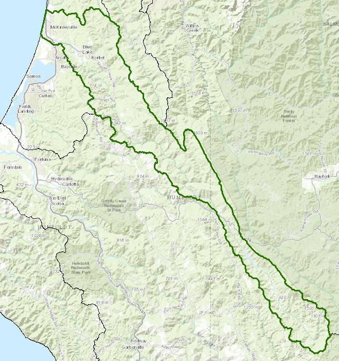
Mad River - Hydrologic Unit 109
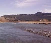
The Mad River watershed is about 500 square miles of mixed private and US Forest Service coastal timberland, with a maximum elevation around 6600 feet and emptying into the Pacific Ocean north of Humboldt Bay. Matthews Dam and Ruth Reservoir provide electrical power and stored water for Humboldt Bay communities via Ranney collectors in the river downstream of the town of Blue Lake.
The Mad River watershed has a long history of timber harvest and gravel mining occurs in the lower portions of the watershed. It is CWA section 303(d) listed for sediment and temperature impacts to the anadromous salmonid resources. The Mad River Hatchery raises steelhead and is run by the California Department of Fish and Wildlife and volunteers from the Friends of the Mad River. The primary issues for the watershed are forestry related, with urbanization and associated industrial and public point sources.
Water Quality, Flow, and Water Rights
Water Quality Assessment Report
Every six years the North Coast Water Board evaluates water quality information and identifies water bodies that do not meet water quality standards and are not supporting their beneficial uses. Those waters are placed on a list of impaired water bodies that identifies the pollutant or stressor causing impairment and establishes a schedule for developing a control plan to address the impairment.
Impaired Water Bodies in the Mad River Unit |
||
Water Body Name |
Listing Extent |
Pollutant |
Clam Beach (near Mad River mouth) |
Entire water body |
Indicator Bacteria |
Clam Beach (near Strawberry Creek)3 |
Entire water body |
Indicator Bacteria |
Mad River |
Entire water body |
Sedimentation/Siltation Temperature Turbidity |
Mainstem Mad River |
Aluminum |
|
Norton Creek |
Widow White Creek |
Indicator Bacteria |
Ruth Lake |
Entire water body |
Mercury |
Main program page:
Map of water quality listed segments. (Click on the map tab)
2007 Mad River TMDL for Sediment and Turbidity
Facilities Regulated by the Regional Water Board
This link is an interactive map of permitted facilities in California. You can zoom in to the watershed of your choice and click on a facility to obtain information.
Sanitary Sewer Overflow Incident Map
This link is an interactive map of overflows from sanitary sewers. You can zoom in to the watershed of your choice and click on an incident to obtain information.
2008 North Coast Water Board's Sediment TMDL Implementation Workplan
The Regional Water Board adopted a TMDL implementation policy statement in 2004 and a subsequent Workplan in 2008 that details efforts to address sediment impaired water bodies in the region
Water Rights Database
Statements of water diversion and use, registrations, certificates and water rights permits are accessible on the eWRIMS, electronic Water Rights Information Management System. This link includes a mapping application.
California Environmental Data Exchange Network
This site, maintained by the State Water Resources Control Board, contains water quality and habitat information in a spreadsheet format. Pay careful attention to the instructions.
California Data Exchange Center
The California Department of Water Resources makes hydrologic information available for hundreds of locations in the state. Specific to the Mad River are:
Water flow and stage
Water temperature, flow, and stage data tables
Landscape Information
2005 N. Coast Water Board Watershed Initiative Chapter, Humboldt Bay WMA
As part of the State Water Board's Watershed Management Initiative, the North Coast Region developed a Watershed Initiative Chapter that provides an overview, a description of its water quality concerns and issues, past significant Regional Board activities in the watershed, activities as of 2005, near-term activities that would benefit the watershed, and activities which may happen on a longer time-scale.
California Geographic Information Portal
This portal has a search engine for the portal itself and ArcGIS online. Information and GIS layers can be accessed for a variety of data, including hillshade, vegetation, rivers, contours, stream fish habitat by reach, stream inventory reports, and CalWater 2.2 maps.
CalFire Fire and Resource Assessment Program
This site contains a wealth of information on the amount and extent of forest and rangelands along with analysis of conditions. Maps, projects, and assessments are available on the site, including GIS layers for timber harvesting, vegetation, and other resources.
U.S. Natural Resources Conservation Service Geospatial Data Gateway
Environmental and natural resources GIS files are available at this site, along with an interactive national map viewer.
Watershed Condition Information
California EcoAtlas
This website provides access to information on wetlands, including integration of some water quality information.
California Coastal Commission
The California Coastal Commission produced a report on the state of Critical Coastal Areas in 2006. The report provides a summary table of conditions and efforts to implement measures to control nonpoint source pollution as well as listing of regulatory and planning jurisdictions and contact information.
California EcoAtlas
This website provides access to information on wetlands, including integration of some water quality information.
Watershed Groups, Partnerships, and Collaboration
Mad River Alliance
This community group is devoted to the protection of the ecological integrity of the Mad River watershed.
Redwood Community Action Agency's Natural Resource Service
This nonprofit group is involved in watershed assessments and restoration activities in the redwood region.
Salmonid Restoration Federation
This nonprofit group was formed in 1986 to assist salmonid restoration efforts in California by promoting "restoration, stewardship, and recovery of California native salmon, steelhead and trout populations through education, collaboration, and advocacy." Their web site contains a wealth of information on salmonids and habitat and stream restoration in California.
California Watershed Network
This nonprofit organization was formed in 2000 to help protect and restore watersheds in California through community-based networks. The website contains some information on watershed events and older information on watersheds of interest, but most of it has not been updated since 2011.
- http://www.watershednetwork.org/
UC Davis Information Center for the Environment, Natural Resource Project Inventory
This database provides information on natural resource projects in California, including links to data and information collected by the projects.
Fisheries and Wildlife Information
CA Dept Fish and Wildlife Stream Inventory Reports
This California DFW site allows searches by major watershed areas, including Mad River tributaries (search on Mad River).
National Oceanic and Atmospheric Administration
NOAA Fisheries is responsible for listing and recovery efforts for anadromous fishes. The 2014 Recovery Plan for coho salmon in the Southern Oregon-North Coast of California ESU contains information on the habitat, population status, stressors and threats, recovery efforts, and recovery strategies.
Strawberry Creek
Norton and Widow White creeks
Mad River
Green Diamond Resource Company
Green Diamond manages a substantial part of the timberlands in the Mad River watershed. Their research arm provides information on the wildlife, fishery, and botanical resources within their lands.
The links and information on this page are provided in an attempt to make a broad range of information available on a watershed basis. While the Water Board has been involved in work within watersheds with a variety of agencies and watershed groups, we cannot vouch for the currency or accuracy of information contained within the internet links we have included. We suggest that you check with the original sources if there is any question regarding currency, accuracy, or origin of information.
Created April 15, 2015; revised February 3, 2016
Web page contact: Robert Klamt, robert.klamt@waterboards.ca.gov(Page last updated 8/29/23)
Water is a precious resource in California, and maintaining its quality is of utmost importance to safeguard the health of the public and the environment.
Statewide Campaigns
EPA Water Sense
File an Environmental Complaint
Save Our Water
Flex Alert
Register to Vote
