Smith River Watershed - Hydrologic Unit 103
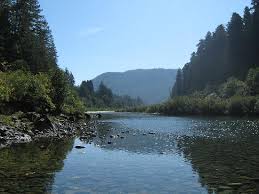
The Smith River is an important free-flowing National Wild and Scenic river in the extreme northwestern area of the Region. This 700 square mile watershed provides substantial habitat for a variety of plant, wildlife, and fish species. The river is known for its clear waters, towering redwoods, and diverse forest community that support anadromous steelhead, salmon, and cutthroat trout.
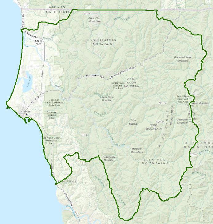
This hydrologic unit also includes Lake Earle and the Crescent City Harbor.
Water Quality, Flow, and Water Rights
2012 Water Quality Assessment Report
Every six years the North Coast Water Board evaluates water quality information and identifies water bodies that do not meet water quality standards and are not supporting their beneficial uses. Those waters are placed on a list of impaired water bodies that identifies the pollutant or stressor causing impairment and establishes a schedule for developing a control plan to address the impairment.
The Smith River has the distinction of not appearing on the list.
Facilities Regulated by the Regional Water Board
This link is an interactive map of permitted facilities in California. You can zoom in to the watershed of your choice and click on a facility to obtain information.
Sanitary Sewer Overflow Incident Map
This link is an interactive map of overflows from sanitary sewers. You can zoom in to the watershed of your choice and click on an incident to obtain information.
Water Rights Database
Statements of water diversion and use, registrations, certificates and water rights permits are accessible on the eWRIMS, Electronic Water Rights Information Management System. This link includes a mapping application.
North Coast Water Board's Agricultural Lands Discharge Program – Easter Lily Bulb Farming
The Water Board has been working on a program to address issues associated with Easter lily bulb farming waste discharges. Some information on the program is available here:
California Data Exchange Center, Department of Water Resources
- Summary of and access to information available at Doctor Fine Bridge (Highway 101)
http://cdec.water.ca.gov/river/smithStages.html - Summary of and access to information available at Jedidiah Smith State Park
http://cdec.water.ca.gov/cgi-progs/staMeta?station_id=JED.
U.S. Geological Survey, National Water Information System for Smith River near Crescent City (Doctor Fine Bridge)
California Environmental Data Exchange Network, "Find Data" query tool
Water quality and habitat data and information are contained at this site in a spreadsheet format. Pay careful attention to the instructions.
Landscape Information
California Geographic Information Portal
This portal has a search engine for the portal itself and ArcGIS online. Information and GIS layers can be accessed for a variety of data, including hillshade, vegetation, rivers, contours, stream fish habitat by reach, stream inventory reports, and CalWater 2.2 maps.
CalFire Fire and Resource Assessment Program
This site contains a wealth of information on the amount and extent of forest and rangelands along with analysis of conditions. Maps, projects, and assessments are available on the site, including GIS layers for timber harvesting, vegetation, and other resources.
U.S. Natural Resources Conservation Service Geospatial Data Gateway
Environmental and natural resources GIS files are available at this site, along with an interactive national map viewer.
Watershed Condition Information
U.S. Forest Service, Six Rivers National Forest, Gasquet Ranger District
Most of the Smith River watershed is within National Forest Service lands.
Watershed Groups, Partnerships, and Collaboration
North Coast Resource Partnership
This partnership began in 2004 as the North Coast Integrated Regional Water Management Plan, and is focused on watershed health, water quality, energy independence, adaptation to climate change, and economic vitality of the north coastal area. A number of funding programs are administered through this partnership. The website contains information on projects within the Smith River watershed:
Smith River Alliance
This watershed organization was founded in 1980 to further protection, restoration, and stewardship of the natural resources in the Smith River watershed.
Salmonid Restoration Federation
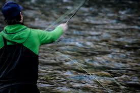
This nonprofit group was formed in 1986 to assist salmonid restoration efforts in California by promoting "restoration, stewardship, and recovery of California native salmon, steelhead and trout populations through education, collaboration, and advocacy." Their web site contains a wealth of information on salmonids and habitat and stream restoration in California.
Fisheries and Wildlife Information
CA Department of Fish and Wildlife Stream Inventory Reports
This California DFW site allows searches by major watershed areas, including Smith River tributaries.
The links and information on this page are provided in an attempt to make a broad range of information available on a watershed basis. While the Water Board has been involved in work within watersheds with a variety of agencies and watershed groups, we cannot vouch for the currency or accuracy of information contained within the internet links we have included. We suggest that you check with the original sources if there is any question regarding currency, accuracy, or origin of information.
January 28, 2016
Web Page Contact: Robert Klamt, rklamt@waterboards.ca.gov
(Page last updated 4/10/26)
Water is a precious resource in California, and maintaining its quality is of utmost importance to safeguard the health of the public and the environment.
Statewide Campaigns
EPA Water Sense
File an Environmental Complaint
Save Our Water
Flex Alert
Register to Vote
